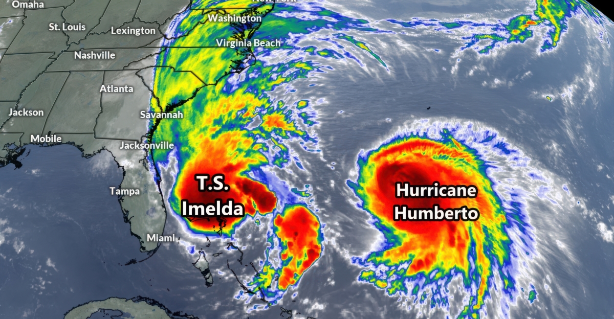
Late September’s NOAA satellite imagery revealed both Hurricane Humberto and Tropical Storm Imelda side by side over the Atlantic.
Humberto (700 mi east of the Bahamas) was a 150-mph Category 4 storm, while Imelda (north of the Bahamas) was a tropical storm at 40 mph. This rare juxtaposition signaled a possible Fujiwhara interaction as their circulations began tugging on one another.
Coastal Threat from Twin Storms
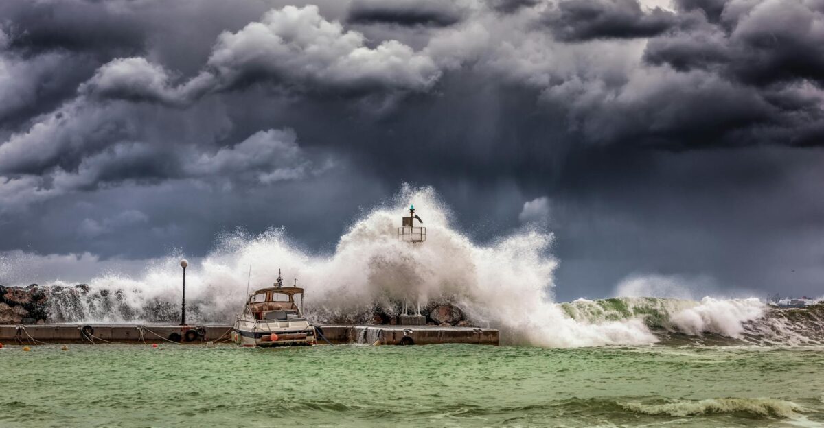
As the storms churned in tandem, they drove massive swells onto U.S. coastlines. Forecasters warned that Humberto’s vast circulation would push dangerous rip currents and 8–12-foot waves far up the East Coast.
Beachgoers from Florida to the Carolinas faced an “ocean furious” situation as unusually high surf pummeled shores normally unaffected by a single storm.
The Fujiwhara ‘Dance’ Explained
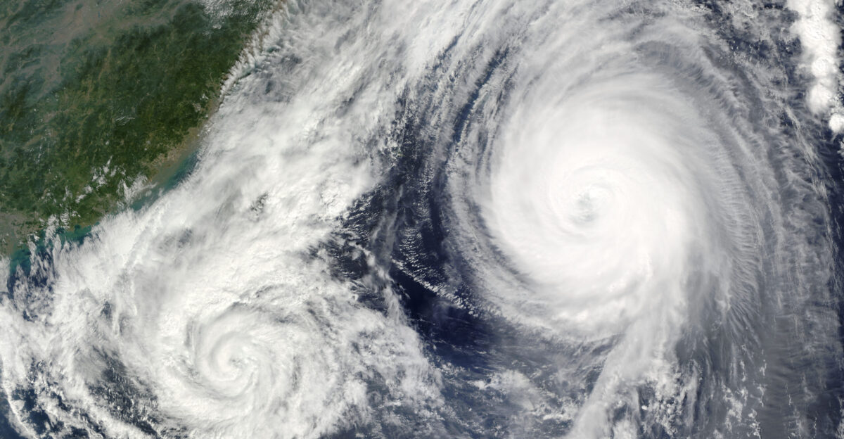
This tandem storm behavior is known as the Fujiwhara Effect. Meteorologist Sakuhei Fujiwhara first showed that when two cyclones are within ~870 miles, they begin orbiting or merging.
Humberto and Imelda temporarily entered a rare hurricane “dance,” each storm’s winds influencing the other’s path as they spun.
Record-Breaking 2025 Season
The 2025 Atlantic hurricane season has been remarkably active. By early October, it had spawned 9 named storms (4 hurricanes, 3 major hurricanes). For example, Hurricane Humberto hit 160 mph on Sept 27 (Category 5) – making it the second Category 5 of this season after Hurricane Erin.
No consecutive seasons have featured multiple Category 5 storms since 2023–24.
Unprecedented Proximity
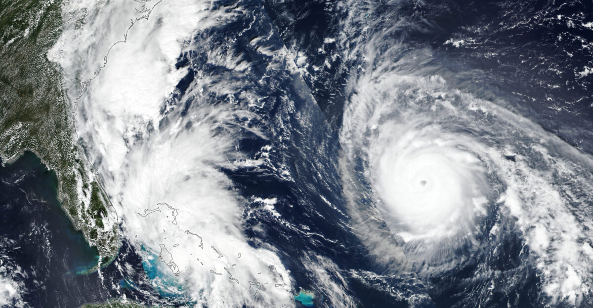
In a meteorological first, Humberto and Imelda closed to just 467 miles apart on Sept 30 – the closest Atlantic hurricane pairing on record.
Storm expert Michael Lowry confirmed, “No two Atlantic hurricanes have been recorded so close” in modern records. This record-shattering proximity was made possible by satellite tracking and underlined the extent of their Fujiwhara interaction.
Bermuda on High Alert

Bermuda braced for Imelda’s arrival. By Oct 1, it was under a hurricane warning, with Imelda a Category 2 at 100 mph and expected to dump 2–4 inches of rain on the island.
Authorities closed schools, offices, and the airport, and deployed 100 soldiers to secure infrastructure. National Security Minister Michael Weeks warned, “This is a dangerous storm system that could bring destructive winds, heavy rainfall, and significant coastal impacts”.
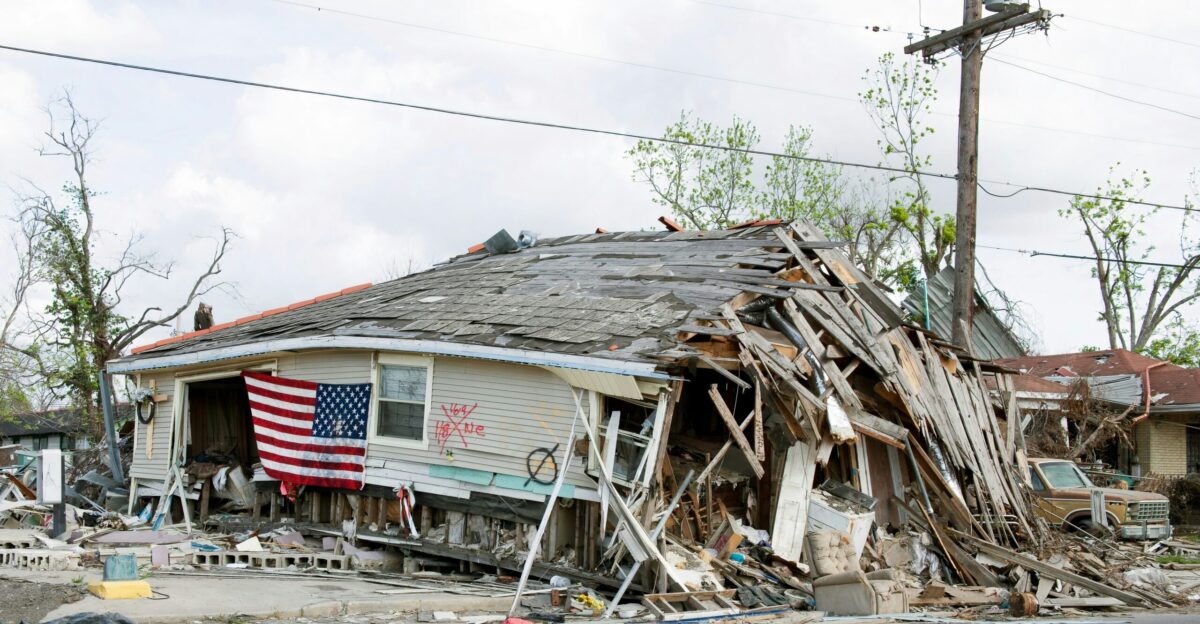
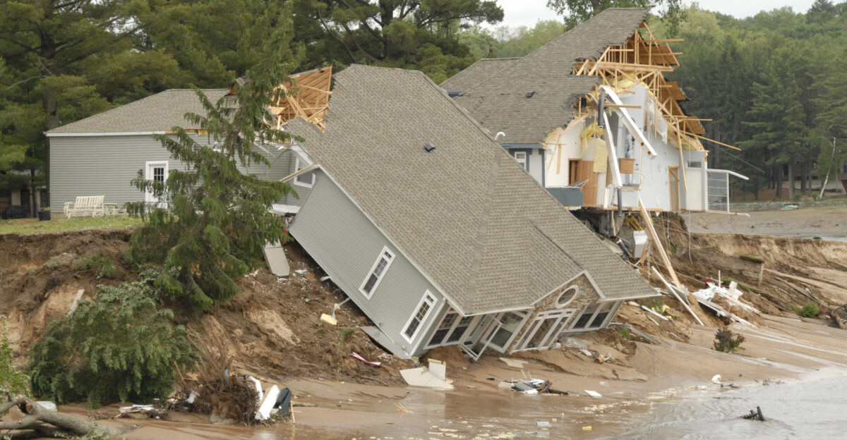
Outer Banks Homes Lost at Sea

North Carolina’s barrier islands suffered severe damage. On Sept 30, six unoccupied beach homes in Buxton collapsed into the Atlantic within hours. One homeowner, Christy Roberson, described watching her house (named “Infinity”) fall: “I looked down … and saw my house falling in the ocean.
It was shocking,” she told NBC News. More buildings now teeter on shrunken beaches as powerful waves undermine pilings.
Distant Casualties

Even far from landfall, the storms proved deadly. In eastern Cuba, Imelda’s flooding and landslides killed at least two people, including a 60-year-old man buried in a mudslide.
Meanwhile, in Florida, a 51-year-old man drowned in Volusia County after being swept away by rip currents driven by the offshore storms. These losses underscore how hurricane hazards extend well beyond the eye wall.
Erosion’s Toll on the Barrier Islands

The Outer Banks’ long battle with erosion was laid bare. As one local planner noted, many homes that once stood a “football field’s walk” from the high tide line are now on the brink.
The National Park Service reports that “eighteen privately owned houses have now collapsed on Seashore beaches since 2020.” Rising seas and stronger storms have steadily eaten away at the narrow islands for decades.
A Satellite Era Milestone

This 467-mile gap is unprecedented in the satellite era. Thanks to space-based tracking (available since 1966), researchers confirmed that no two Atlantic hurricanes in recorded history have come this near.
This scientifically documented extreme proximity – tighter than any in NOAA’s database – provides new insight into storm interactions in the climate-change era.
Forecasting in Uncharted Waters
Emergency managers found it hard to pinpoint risk amid the Fujiwhara interaction. Traditional track models faltered when two storms began tugging on each other.
The National Weather Service issued broad flood and surf warnings; in eastern North Carolina, it noted that “dangerous surf conditions were expected through the rest of the week.”. Officials urged the public to stay off closed beaches, even as debris fields grew.
Government Emergency Measures

Governments mobilized quickly. Bermuda’s military and shelters were on standby as residents faced the onslaught. In North Carolina, the Cape Hatteras National Seashore was closed to protect people from debris and unstable structures.
State transportation teams deployed graders and suspended ferries when waves overtopped NC Highway 12. Even without a direct landfall, officials treated this as a major emergency, preparing for heavy cleanup and flooding.
Cleanup and Recovery Challenges
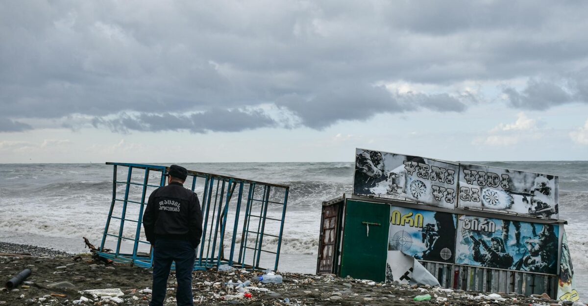
After the waves receded, miles of beach were littered with wreckage. Satellite videos showed houses plunging into the surf and littering the shoreline with lumber, insulation, and furniture.
Park Service crews warned visitors to avoid the debris. In the weeks ahead, communities and insurers will grapple with dozens of damaged homes – deciding whether each can be repaired, must be demolished, or should be relocated inland.
Local and Weather Experts Sound Off
Local voices captured the devastation: as one area realtor put it bluntly, “Buxton’s in a bar fight,” referring to the battered coast. National experts echoed the sentiment of an extraordinary season. AccuWeather hurricane specialist Alex DaSilva said, “This hurricane season so far is quite unique, with several close calls for the United States.”.
Forecasters cautioned that months of stormy conditions may still lie ahead, even as the cleanup begins.
Worsening Trends Fuel Questions
Two Category 5 hurricanes in one season are part of a troubling trend. Humberto’s brief surge to 160 mph made it the 44th Atlantic hurricane ever to reach that intensity – and the 12th to do so in the last decade.
Scientists are investigating whether unusually warm ocean temperatures are fueling stronger storms and making interactions like this more common. Early indications suggest the stakes are rising for coastal areas.
Debate Over Coastal Policy
The Outer Banks crisis highlights policy dilemmas. North Carolina officials recently valued Dare County’s barrier-island oceanfront at about $18 billion. Yet a 2024 study found roughly 750 of the state’s ~8,800 beachfront structures are now at erosion risk.
Lawmakers are weighing expensive measures – beach renourishment, seawalls or buyouts – to protect communities, but debate swirls over how much taxpayers and homeowners should absorb.
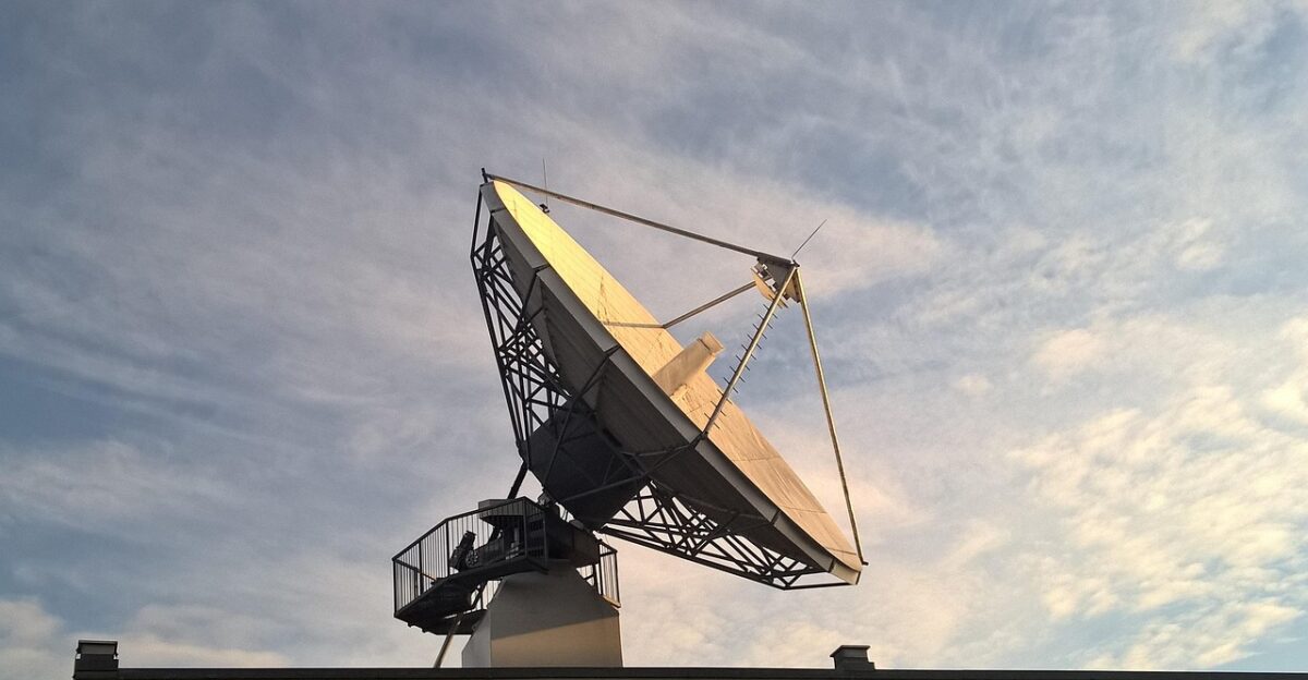
Global Satellites Track Storms

New space assets gave researchers unprecedented data. On Sept 28, Japan’s EarthCARE satellite (nicknamed Hakuryu, “White Dragon”) passed directly over Humberto’s eye as it re-curved off the U.S. coast.
This rare straight-overpass lets scientists map vertical cross-sections of the storm’s clouds and rain. Together with NOAA’s geostationary imagers, the international constellation provided a detailed 3D view of these twin cyclones.
Insurance Industry Reassesses Risk

Insurers are recalibrating how they value coastal risk. Many “500-year” hurricane scenarios are occurring repeatedly, prompting some carriers to hike premiums or withdraw from barrier-island markets. The Outer Banks losses total in the millions and raise thorny claims issues – insurers will argue whether damage was caused by wind, storm surge or preexisting erosion.
Observers note that federal buyout funds and stringent building standards may be needed just to keep up with escalating losses.
Changing Attitudes Toward Coasts
Viral videos of homes collapsing have catalyzed national debate about coastal development. Younger residents, in particular, are questioning rebuilding in high-risk zones. Homeowner Christy Roberson said of the vanishing “Infinity” house: “My moments in Infinity and the moments shared there will always be the love story” – a poignant reminder of what is lost.
Another Buxton local sighed that “it really is paradise, but there’s always a price to pay,” reflecting a sense that the romance of oceanfront living is under siege.
Preparing for the New Normal

Experts warn that Humberto–Imelda may be a harbinger. As Alex DaSilva cautioned, “We expect atmospheric conditions that could support tropical storms and hurricanes well into late October and November this year.”
With ocean temperatures on the rise, consecutive storm interactions and near-misses could become more common. Scientists say coastal communities must overhaul hurricane preparedness and retreat strategies – expecting that record-breaking proximities might become the new normal in the decades ahead.